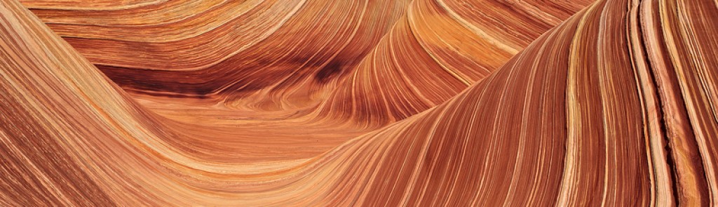
Goosenecks, Ruins, and Badlands – Goosenecks State Park, Cedar Mesa, and The Bisti Badlands
A couple of weeks ago I set out on my way to Utah not sure exactly where I would end up. My original plan was completely different but with storm clouds in the distance and rain predicted I decided it was a good idea to play it safe on the desert roads and I headed to the Cedar Mesa area for a couple of days. The trip was good and I was able to explore a couple of places that I have always wanted to check out.
I ended up camping at Goosenecks State Park, just below Cedar Mesa. Other than the parking lot style campground I really can’t complain. The views were great and my photo spot for the shoot was about ten steps away from my campsite.

After a beautiful sunrise I headed to Moon House Ruin in McCloyd Canyon. The road in wasn’t too bad, and with one eye watching the storm clouds around me and the other on the trail I made my way down to the ruin. It was worth the effort to get there, being a well-preserved ruin with some pretty unique characteristics. The main one being the painted wall on the inside hallway of the ruin.

After Moon House I headed back down from Cedar Mesa and took a detour along Valley of the Gods Road, something I have always been meaning to do. I was pretty impressed by the road and there seemed to be some really nice campsites. I will definitely be going back to shoot that area sometime soon.

After that I decided to head for the Bisti Badlands, hoping that the storm clouds would offer some nice shots of the badlands bathed in storm light. Unfortunately the storm light didn’t last too long but I still spent the evening and the next morning exploring a bit. The Bisti never seems to disappoint, there is always something to explore and something to shoot.

Overall another beautiful trip in a beautiful place!
Gear Review – GSI Drip Coffee Maker
Possibly my favorite piece of backcountry gear! The GSI Ultralight Java Drip Coffee Maker is awesome!
I can’t say enough good things about this simple, inexpensive, recent addition to my backcountry gear collection. If you’re like me you like a nice cup of fresh brewed coffee in the morning. And if you’re like me than you often find yourself in places that don’t exactly offer an easy way of brewing a nice cup of coffee. Enter the GSI Drip Coffee Maker.

This simple device truly turns my mornings spent in the field chasing good light a joy. To use it I just boil some water on my stove. While the water is boiling I attach the three small plastic clips on the bottom of the coffee maker onto my mug, put a cone filter into the hanging mesh bag (this is not necessary but I find it drips slower this way making a better brew), and then spoon my coffee into the filter.
When the water is done boiling I pour it slowly over the coffee and voila, an awesome cup of coffee! I’ll tell you that this beats all other methods of backcountry brewing that I have tried, including instant coffees and french presses. Hands down one of my most valuable pieces of backcountry gear!
Free PDF Download – “Loose Prints-Why?”
I have put together a free PDF Download, “Loose Prints – Why?” which contains some information for those contemplating purchasing a Fine Art Print but aren’t sure whether they should get a framed / mounted print or a loose print. This PDF gives the basics of what a loose print is and what you can do with it. It also gives a brief overview of what is meant by archival quality and why it is important when considering how to frame, mount, and display your print.
To receive a link to the free PDF just follow this LINK, enter your email address to sign up for my Email List, and a link to the PDF Page on my website will come in the confirmation email.

Free Download – Just click the link above and sign up for my Email List to receive your download!
Black Smoke and Wildflowers – Durango and Silverton Railroad to the San Juans
Last week I bit the bullet and did something I’ve been meaning to do for a long time. I embarked on a unique journey into the backcountry in search of some summer wildflowers using the Durango and Silverton Narrow Gauge Railroad (DSNGRR) as my approach to the wilderness, a highly recommended mode of backcountry travel for those that have never tried it.
A little background, the DSNGRR was completed between the towns of Durango, CO and Silverton, CO in 1882 to haul workers up to the mines and gold and silver ore down from the rich mining country high in the San Juan Mountains back. Originally the Silverton Branch, as it was known, was built and operated by the Denver and Rio Grande Railroad connecting to the mainline which at that time connected Durango to Denver. In 1980 the last train under the Rio Grande Railroad left Durango and the next year the line between Durango and Silverton was purchased as the Durango and Silverton Narrow Gauge Railroad, with a greater emphasis on passengers and the use of the route as a “scenic railway.”
My journey started at the Depot in Durango where I quickly and effortlessly loaded my backpack onto a rail car with the help of the conductor and took my seat for the three hour ride north to Elk Park along the Animas River, deep in the backcountry of the San Juan Mountains. The ride itself is very scenic, carving it’s way along the cliffs high above the Animas River and then dropping down belong side the river for the duration of the trip.
Once at Elk Park it was a quick departure from the train where the conductor handed down my backpack and I was left at the side of the tracks watching the black smoke of the Steam Locomotive pull away around the bend and out of sight. Standing there I couldn’t help but think that this must have been at least partly what it was like back in the 1880’s when workers, miners, explorers, hunters, trappers, etc. were let off the train in the middle of the mountains, maybe making there way out to some lonely mining claim or trapper’s cabin now lost forever in this vast wilderness.

The DSNGRR steams off after dropping me at Elk Park, deep in the San Juan Mountains.
For me the journey had just begun, I shouldered my pack and headed up the trail toward Vestal Basin, my destination for the night.
I guess I should have done a little bit more research on the route up to Vestal Basin from the Elk Creek Trail, my thought was that I had found the drainage on the map and I figured that I would find the “goat trail” along the drainage once I got there as long as I found the right drainage. Well, I was wrong. I arrived at the Beaver Ponds in roughly two hours, not bad time so I figured I was doing good. I stopped and drank some water, enjoying the beautiful peaks all around me. I spent a little time trying to find the best route across Elk Creek and up the drainage that I knew from the map led eventually to the basin beneath Vestal Peak. I figured I would head up the drainage and at some point I was sure I would find the trail that I had read about.
My epic adventure began with several creek crossings leading me into a very thick thicket which was laden with heavy downed timber. It was a nightmare to say the least. On top of that there were swarms, and I do mean swarms, of biting flies that seemed to be attacking me in organized assaults.
I figured it would take me about three hours to get up to the basin from the Beaver Ponds on the Elk Creek Trail, putting me at the basin around 5 ‘o’ clock, plenty of time to eat and scout out a location for sunset. That plan fizzled when the endless deadfall and thickets droned on for as far as I could see. About 5 ‘o’ clock I found myself in a small clearing on the side of the drainage, still unsure where exactly I was at in regards to the basin that I was trying to get to. I knew I was in the right drainage from looking at my GPS but I really had no idea where the “Basin” was at. I came close to calling it a day, throwing my tent up in the desolate opening and figuring it out in the morning. I was truly exhausted and I could barely stand the thought of putting my pack back on and battling more thicket and deadfall in an effort to find the basin in which I had no idea lay how far in front of me.

My Fstop Gear Tilopa Pack, packed to the brim. Notice the swarm of biting flies attacking the pack!

An exhausted me, about mid-way along my bushwhacking adventure along Vestal Creek. The bandana is to keep my head from getting attacked by the onslaught of biting flies!
For some reason I got a wild hair and decided to do just that, I threw my pack on and battled my way further up the drainage toward, gaining more elevation, and becoming more and more exhausted. Hoping that I would find another relatively flat place for my tent before night overtook me. Another hour and a half into my adventure I got a view down into the valley from the high spot on the side where I was at and down in the valley I saw fields of wildflowers, a creek, and lo ad behold, a trail. There it was, the fabled Vestal Creek Trail. I was about four hundred feet above the trail battling deadfall and thickets high on the side of the valley.
I quickly readjusted my route and scrambled down a scree field into the basin, arriving on the trail to find a guy gathering water at the stream, he was pretty startled when I stumbled out of the thicket and onto the trail. I told him about my epic journey and his buddies joined him, all looking rather astonished that I had just bushwhacked five miles at a steep grade through the drainage to get there. I’m pretty sure my haggard and exhausted appearance probably added some validity to my story. None the less, they told me that they had only gone a short ways further on the trail but they had spotted some decent campsites a short ways up. I stumbled the couple hundred feet to the woodbine where I found a perfect campsite nestled in the pine trees next to a beautiful mountain stream.
The fact is, I could have dropped my gear and got my camera out since the sun was just setting and perfect light was just then illuminating the valley in a beautiful story. However, I was beat down and exhausted, the only thing I could think about was the Mountain House I had just hauled all the way up here and getting my tent up before dark. My body was ridiculously sore and I couldn’t even imagine trying to shoot images at that point. So for the first time in my life I chose food and setting up camp in place of shooting a beautiful sunset. I did actually manage to snap a few images after dinner as the sun was setting but they really didn’t amount to much of anything. After that it didn’t take long at all for me to hang my food and hit the sack. I was done.

In the words of John Denver, “I’ve seen it raining fire in the sky.”
The next morning I managed to drag myself out of the tent just as the first light of day was starting to touch the peaks around me. It was a gorgeous display of Mother Nature’s beauty and probably the best photo shoot of the trip. A gorgeous field of wildflowers beneath towering peaks above.
Arrow Peak as seen from Lower Vestal Basin.
I figured I had kind of wasted the first day of the trip battling downed trees and thickets, but I was determined to make the most of the trip. Especially since I was now in such a beautiful area. I ate some breakfast, brewed some coffee, and packed up my camp, intent on moving up to tree-line to position myself well for some sunset and sunrise photos from the Upper Basin. I made my way pretty quickly from the Lower Basin to the Upper following a somewhat scant trail. Just as tree-line was petering out I found what appeared to be a decent place to camp with a few sparse trees set up on the walls of a small depression. I figured that the sparsely surrounding trees should offer some protection in the case of a thunderstorm.
With that, I headed up into the Upper Basin to scout some sunset and sunrise locations as well as to get a good lay of the land. I spent the afternoon exploring, always keeping a watchful eye on the sky above. Clouds were rolling in and out all afternoon but nothing seemed to be very threatening.

A lone Columbine high in the beautiful desolation of Vestal Basin.
I decided to eat dinner next to a nice little lake high up in the basin. Ok, so in my recent efforts to make my gear lighter and more compact I recently purchased an OliCamp Ion Micro Stove and in my preliminary testing it seemed that the stove was a little bit unreliable in any amount of wind. My solution for this was to build a small lightweight windscreen out of a piece of titanium. I had read the warnings about not using a windscreen with a canister stove, but I didn’t really pay it too much mind. So I fired up the stove with the titanium windscreen around it and sure enough, it worked good, too good. It only took about a minute before the canister started smoking. I quickly turned it off and let it cool down. The paint on the canister had turned black and the seal around the lip of the canister had started melting out. When I touched the melted coolant it cracked and all my gas leaked from the canister. Hmmm, lesson learned I suppose.

A large scree field spilled down the side of Upper Vestal Basin with a small lake surrounded by scree.
With that I finished my dinner and then noticed a large black cloud approaching. I couldn’t see any lightning in the distance or hear any thunder but I figured better safe than sorry so I relocated to the Middle Basin to shoot the evening. I found some nice wildflowers and good waterfall in the Middle Basin so it was still a pretty successful evening. The storm clouds seemed to dissipate and break up right at dark and I figured I was in for a good night’s sleep with an early wake-up in order to shoot the Upper Basin at sunrise.

Sunset and alpenglow on Trinity Peaks as seen from Middle Vestal Basin.

A close up shot of Vestal Creek near it’s head in Middle Vestal Basin.
About an hour after dark I was woken up to the deafening booms of almost constant thunders. The valley around me was aglow with lightning. One bolt shot down after the other, illuminating the peaks around me in a terrifying blue and yellow glow. I sat huddled in my tent, wondering if my campsite was indeed a good spot or perhaps I should be down the mountain a little further where there were more trees. After an anxiety ridden hour of huddling in my tent I decided to pack it up and make a quick dash down the mountain in search of better shelter. At this point there was still no rain with the storm so I figured if I hurried I could make it without getting wet.
Of course as soon as I got my tent down the rain unleashed and it was a downpour, I threw on my rain jacket, packed my gear and took off down the mountain via headlamp. It probably took me about 45 minutes to navigate down the slippery goat trail in the rain and the dark. Eventually I found a spot in the trees which made me feel 100% better about sleeping away the lightning-filled night.
I quickly sat up camp and fell asleep to the sound of booming lightning and hail peppering my tent.
I had my alarm set to go off at 0400 in hopes that I could catch a clearing storm in sunrise light, but no such luck. 4am rolled around and the rain was still coming down in sheets so I decided to tuck myself deeper into my sleeping bag and wait out the storm. Finally about 0800 the storm cleared and I crawled out to find a beautiful morning waiting for me.
At this point I was still exhausted from my uphill bushwhack on the way in and the storm last night had frazzled my nerves. I decided to chalk this one up as a learning experience and head out to Elk Park to catch the train back to Durango. I made it to the train stop, caught the train, and bought a nice cold beverage, traveling in style all the way back to the depot in Durango where my wife and daughter picked me up. I felt beaten down and ragged, but smarter and wiser for the experience.
Beauty in the Land of Rustlers – Robber’s Roost
The Preface
Robber’s Roost is an area of Utah due south of the town of Green River and on the western side of the actual Green River. The area is extremely remote and rugged which made it an ideal hideout for outlaws and cattle rustlers in the late 1800’s and early 1900’s. Most notably Butch Cassidy allegedly formed his gang, The Wild Bunch, in the rough and broken land of Robber’s Roost thus inspiring the name of the area.
Today Robber’s Roost doesn’t hold much in the way of cattle rustler’s or train robbers but the land is still rugged, remote, and beautiful. The recent epic story of Aron Ralston’s survival after being trapped by a boulder in Bluejohn Canyon took place in this area as well. Bluejohn Canyon is just one of the many large canyon systems in the area that hold in their secret depths some of the most technical canyoneering to be found in the Four Corner’s Area.
The Approach
Myself, not being a cattle rustler, a train robber, or a particularly-technical canyoneer, I found myself in, “the Roost,” as it is commonly called after a bit of a different type of adventure. While some of the canyons offer a myriad of technical rappels and keeper potholes to navigate there are a few other small canyons that offer deep dark narrows and slots that when caught in the right light inspire visions of nature’s beauty that are seldom if ever seen anywhere else in the world.
My journey only lasted a couple of days but the beauty was indisputable. It started with an evening departure from Durango, CO, my route taking me into Utah and through the Cedar Mesa area where I had an overnight bivouac in the front of my truck. I was originally planning on driving all the way to Hanksville the first night but the dark and lonely road got the best of me and I decided it was better to pull over rather than to plow into one of the many deer that seemed to be jumping out in front of my truck.
On the second day of my trip I woke up early to the whomping racket of what sounded like a freight train slamming into my truck, since there were no freight trains anywhere to be seen I quickly realized that it was the wind that was making my truck sound like a rock concert gone bad. It turns out that the whole area was being hit by a large-scale wind event and as it turned out the wind would not let up the entire time I was out. Twenty to thirty mph sustained winds with gusts even stronger than that, it was definitely a bummer but more to come on that later.
For now I was back on the road headed towards Hanksville. After a quick stop to top off my fuel I turned off of UT24 north of Hanksville at the signed turn for Horseshoe Canyon. The wind was blowing so hard that the dust I was kicking up while trucking along the dirt road was actually moving faster than my truck was, therefore creating a bit of a problem for driving. None the less, I found my way through the dust clouds and wind-blown sand to the intersection with The Maze Road and headed south for another 26 miles or so to the Han’s Flat Ranger Station. On the way it seemed that off to the east there were some pretty dark clouds forming and all around there was cloud cover with intermittent breaks of blue sky. Not exactly what seemed like ideal slot canyon conditions, let alone really remote and solo slot adventures.

While on the Maze Road I stopped to say hi to a couple of guys eating lunch near their vehicle and asked what they thought of the weather, the last time I had looked at the weather report it called for ,”windy and clear conditions.” The wind was definitely there but the clear, not so much. The two guys said they had heard the same thing but it didn’t much look like clear weather to them either. They said they were going to keep their eye on the weather but they were still planning on doing Bluejohn Canyon. I wished them well and told them I was off to the High Spur. They wished me luck and we parted ways.
I arrived at the Han’s Flat Ranger station under partly cloudy skies and the wind making it difficult to stand without leaning into it. I asked the ranger inside what the road condition up to the High Spur was like, he casually leaned over, looked out the window at my truck (a stock Tacoma) and said, “you’ll be fine in that.” With that I asked him if the weather report had somehow changed from clear to storms? He looked it up on the internet (I think it’s wild that they have internet in such a remote outpost), the weather still said, “…windy and clear.” With that I said thanks and walked out the door into the gale force wind and the gathering clouds that could be seen in all directions.
The road north from the Hans Flat Ranger Station was in good condition with just a few relatively rough spots over the slickrock and it took me about an hour and fifteen minutes to drive the 13 miles to the intersection of The Spur Road and Deadman’s Trail. A spot in the vicinity of the canyon I was looking for, The Northeast Spur Fork, otherwise known as The High Spur.
These photos of the road are actually from the drive out but it gives a good idea of the road condition and what to expect…


And one of the camping / parking near the intersection of The Spur Road and Deadman’s Trail… Note the rather ominous looking clouds to the east!

The Upper Canyon
I took another look at the clouds around me and decided that the dark clouds were off to the East and with the gale pounding out of the West it seemed safe to assume that I was in no present danger of a storm. With that I packed up my camera gear and some light-duty canyoneering hardware and made my way toward the upper part of the canyon. There was a meager hiker’s trail leading from the parking area to a small drainage that I followed down to the upper portion of the slot. At this point it was easy to find a way down into the sandy wash which quickly became a narrow passage between tall sandstone walls.

The upper portion was easy to navigate with several one meter steps to negotiate but nothing overly ambitious. About a half hour into my trek I came to my first obstacle, it was a downclimb of about two meters, since I had little idea of what lay in store for me down the canyon (other than the beta from a Kelsey book, which I always take with a bit grain of salt) I decided to rig a handline so that I could get back up the downclimb without too much difficulty if the need arose. About five or ten more minutes down the canyon there was a second downclimb, a little bit higher, and this one seemed a bit harder if I wanted to come back up it, so I set up a second handline just in case.
Not too long after that I came to an opening in the canyon with what seemed like several gullies making their way to the canyon rim so I decided to return up the canyon and retrieve my gear before continuing down the canyon.
After this opening the canyon got very narrow forming the first real slot portion, it was a fantastically narrow area of twisting and curving sandstone, logs wedged between walls, and wind-blown sand hammering me in the face.
Another hour or so down canyon, after intermittent slot sections and open narrows sections, I came to the area in the canyon where Kelsey shows a “steep entry/exit.” It was easy enough to spot, a steep rock-strewn gully that seemed to breach the top of the canyon rim. It was only three ‘o’ clock but a little bit early I had taken a fall while stemming a short narrow section. The wind had blown fine dust all up and down the walls of the canyon and while I was frictioning a foot placement my foot completely slid off the wall and tumbled down onto my left side, scraping myself up a little and bruising my left thigh. I decided that I had a good day and felt satisfied to return to the truck and get a fire going for dinner.
The steep climb out wasn’t actually as bad as it first appeared and it did indeed get me to the top of the canyon rim with a short walk to Deadman’s Trail and a short walk along that back to camp. Of course when I arrived in camp the wind was still coming in like a hurricane and I decided a campfire was probably not a good idea, instead I warmed up some beef stew on the stove in the back of my truck and curled up with a good book. The wind continued to hammer my truck and I fell asleep dreaming of a terrible storm blowing in during the night.
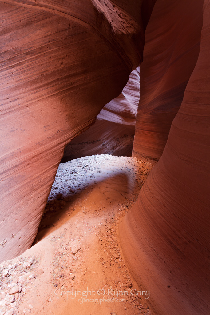
The Lower Canyon – Corkscrew Slot
Lucky for me it was only a bad dream, I awoke to find clear blue skies. The wind was unfortunately still blowing like a banshee but at least the skies looked less menacing which gave me a better feeling about the day. I decided that I wanted to skip the middle portion of the canyon and go directly to the famed “Corkscrew” area to see if I could get some good shots. In order to make my trip a little shorter I drove Deadman’s Trail to the Pinyon / Juniper Camp marked in Kelsey’s book. The Deadman’s Trail was easy to drive except for the one spot (also marked in Kelsey’s book) that required a little bit of finesse and perhaps four-wheel drive as well. The bad spot is a series of two rock steps, neither one of them are truly horrible, but just steep enough that I think a two-wheel drive might need a little bit of gunning to get up.
After that I found the Pinyon / Juniper Camp and it seemed like a pretty nice place to camp, much nicer than my spot the last night which was very exposed and open.
Once again I quickly packed up my stuff, filled my water bladders, and thew some light canyoneering gear into my pack. I headed out from the camp following a wash down to the canyon rim. I then followed the rim around to a spot where I figured I could work my way down to a lower shelf, then I found a trail which brought me out once more into the sandy bottom of the Northeast Spur Fork. I turned right and immediately found myself walking into a tight twisting slot section. It was late morning at this time and I spent about an hour shooting images in this section with nice light bouncing between the red canyon walls.
I was stopped by a steep downclimb of about three meters that looked like I would definitely need to set up a handline of some sort in order to get back up. From reading Kelsey’s description of the canyon I figured that this downclimb was the one immediately before the rappel at the bottom of the technical part of the canyon so I figured I would just stay up on top of the downclimb and shoot photos, not bothering with rigging any gear.
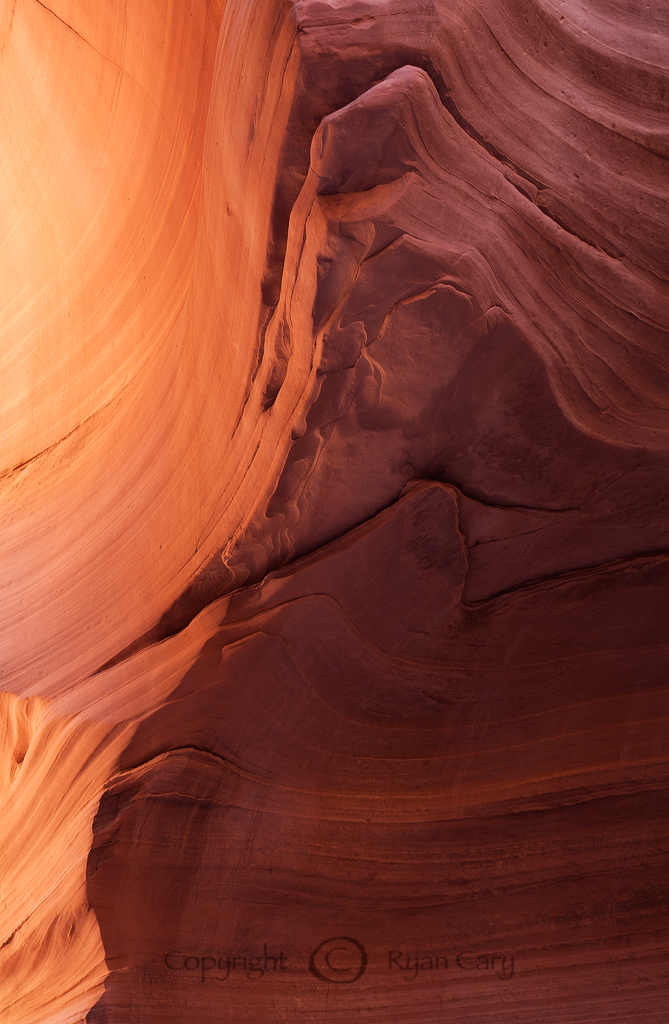
Mud Curls, Northeast Spur Fork
This image is available for purchase as a Fine Art Print. For more information please go to ryancaryphoto.com.
After about an hour I was packing up my stuff and curiosity got the better of me so I decided to go ahead and rig a handline down to see what there was to see. I am very happy I made that decision, below the downclimb was not the rappel, but instead a deep and beautiful chamber that seemed reminiscent of Antelope Canyon in many respects. I ended up spending about two hours there shooting images. The chamber was deep enough that the wind was not even reaching me, the only problem was that with it still blowing above me sand and rocks were constantly being blown off the rim and dropping down all over my camera gear and my head.
The dark and delicate beauty of the place was truly breathtaking and it was worth a bit of sand being blown down to capture some beautiful images of one of Mother Nature’s masterpieces.

Northeast Spur Fork Detail #1
This image is available for purchase as a Fine Art Print. For information please go to ryancaryphoto.com.
Northeast Spur Fork Detail #2
This image is available for purchase as a Fine Art Print. For more information please go to ryancaryphoto.com.

Corkscrew Chamber Detail #1
This image is available for purchase as a Fine Art Print. For more information please go to ryancaryphoto.com.

Corkscrew Chamber Detail #2
This image is available for purchase as a Fine Art Print. For more information please go to ryancaryphoto.com.
Another beautiful trip in a remote and beautiful place. I didn’t find any robber’s treasure but Mother Nature left some treasures of her own to discover here for sure. Definitely worth a return visit for sure!
Lone Tree Photography Show 2014
I am pleased and honored to have had one of my images, “Reflections,” chosen by Juror Glenn Randall to be included in the annual Lone Tree Photography Show, now called Exploring the Light. The show will run from April 19, 2014 through June 8, 2014 at the Lone Tree Arts Center in Lone Tree, Colorado. The opening reception will be held from 3pm – 5pm on Saturday, April 19th. I will be in attendance and I am looking forward to seeing some spectacular photography! Come join the fun!
For more information regarding the show follow the link below.
Drop me an email or post a comment if you think you might show up so I can look for you in the crowd! Cheers!

Prices 2014
Just an update. In an effort to always stay current and competitive in the field of Fine Art Photography I have updated my prices. You will notice that most of the prices have actually gone down slightly due to the current trend. Here is a direct link to the Print Pricing Page on my website if you want to take a look!
Happy Canyon Backpacking
A couple of weeks ago I took advantage of the unseasonably warm weather and decided to check out a place that has been on my list for some time, Happy Canyon. Just like most folks, due to the remoteness of the canyon I unfortunately only had a couple of hours to shoot the narrows before I had to head back toward camp, but none the less it was a great trip. Here’s a brief overview.
I started out on Poison Springs Road well after dark and made it about five miles down the road before ice-flows over the road had me too worried to continue. I spent the night camped next to a sandstone wall that the next morning I found to contain some gratified rock art. After checking out the rock art I packed up and headed on my down Poison Springs Canyon Road toward the Black Jump. For this trip I decided that a bike would be helpful to aid my approach so hoisting my 40+ pound pack I pedaled my way down the sandy road. I have to say that this was my first experience carrying a pack on a bike and I’m really not sure if it was more of an aid or a hindrance. I ended up pedaling most of the way barring a few really sandy spots on Poison Springs Road.
Once at the Black Jump I ended up pushing my bike most of the way up the mining road that veers up toward the North along the Dirty Devil River Canyon. My legs were pretty much done by this point so after a ways up the road I stowed my bike behind some rocks and continued on foot, eventually making it to the First Point, as it is locally known, around 1530. My original plan was to camp much nearer the descent to Happy Canyon however my legs were cramping from all the pedaling through deep sand so I decided to call it a day and leisurely set up camp.

I woke up early the next day, a little before dawn and headed down the road toward the descent spot, eventually reaching the dirty devil river about 1000. The crossing went well and the water was about mid-thigh depth, the main obstacle being watching for ice chunks floating down the river toward me. On the other side I dried off and sunned myself for awhile before exploring the Narrows of Happy Canyon.
I enjoyed about three hours of shooting in the canyon before I figured I had to start heading back to camp. The canyon was beautiful and I think that with more time available I could have found some really nice shots. As it was I still managed to come away with a couple decent images.


After the canyon I figured the crossing at the Dirty Devil would be deeper due to snow-melt. The water ended up coming up to the bottom of my shorts and it was definitely more powerful. I still made it across without incident. And the climb back up the drainage toward the road was without incident as well. From river to camp I ended up making good time, only taking about two hours.
The evening was spent eating and rehydrating with dark brown Dirty Devil River water… mmmmm…
The next morning I packed up and headed back toward my truck, still parked near the rock art on Poison Springs Canyon Road. The trip back took me about five hours.
All in all I believe I ended up hiking/biking about thirty miles in three days and had about three hours to shoot the narrows. The trip was a great introduction to the area but in the future I think I will plan it a little different so I have more time in the canyon. Still a great trip all in all.
Open Shutter Gallery “Exposure” Exhibition 2013
I just wanted to let everyone know that one of my images will be shown in the upcoming “Exposure” Exhibition at the Open Shutter Gallery in Durango. The opening reception for the exhibition is December 6th at 5pm and the show will run from December 6th to January 9th, so come and take a look if you’re in the area!
Marlboro Point Sunrise
Not too long ago I had a quick trip planned to go shoot a ruin on Cedar Mesa in Southeast Utah that I had been trying to find for quite some time and finally had figured out where it was. Unfortunately the stars were not in alignment because as I drove through the darkness, passing through Bluff, the radio reports were pretty explicit in the fact that a large storm was inbound for the area. The storm itself didn’t scare me but I was thinking of the many miles of dirt roads that I had to drive to get to the canyon that I wanted to explore and the thought of all that mud made me think twice about embarking out on them that night so I decided to sleep the night at the Kane Gulch Ranger Station and reassess the situation in the morning. I would say it was probably a good call as I awoke in the middle of the night to pounding rain and hail coupled with a magnificent show of lightning.
The morning dawned with a downpour and more hail so I decided I needed to reevaluate the situation and headed for Moab where I knew I could take advantage of the dramatic weather and maybe pull off a good shot from one of the vantage points on the Island In The Sky. I hadn’t thought about the fact that the parks were all closed due to the government shutdown until I arrived on top of the Island In The Sky and saw the police tape and “Closed” signs at all the Federal Sites, including Canyonlands National Park.
At this point I was kind of bummed but I remembered someone telling me about a locally known viewpoint known as Marlboro Point so I did a little map recon and figured out where I was headed in the morning.
It was a bit of an adventure walking across the desert in the pitch black trying to find this spot of rock on the rim of the canyon mesa but I did manage to make it just as the sun was starting to rise.

My reward for the effort was a beautiful sunrise overlooking the desolate canyons and desert below, what a way to spend the morning. On my hike out I saw none other than Brett Edge, a local Moab Photographer, headed out to the point with a client. Of course Brett was driving down a four-wheel drive road that is not on the map, that happens to head right to Marlboro Point. Next time I think I’ll drive the road, but this time the effort was worth it.
